Destination

Hushe Valley

Hushe Valley

Where Granite Meets Glacier

Hushe Valley sits at 3,100 metres in Ghanche District, Gilgit-Baltistan, carved by the Hushe River as it descends from Masherbrum (7,821m) toward the Shyok River near Khaplu. The journey from Skardu takes six to eight hours: four hours on paved road to Khaplu, then two more by jeep on an unpaved track into the valley. That final stretch is the filter. It separates those who want convenience from those who want something real.

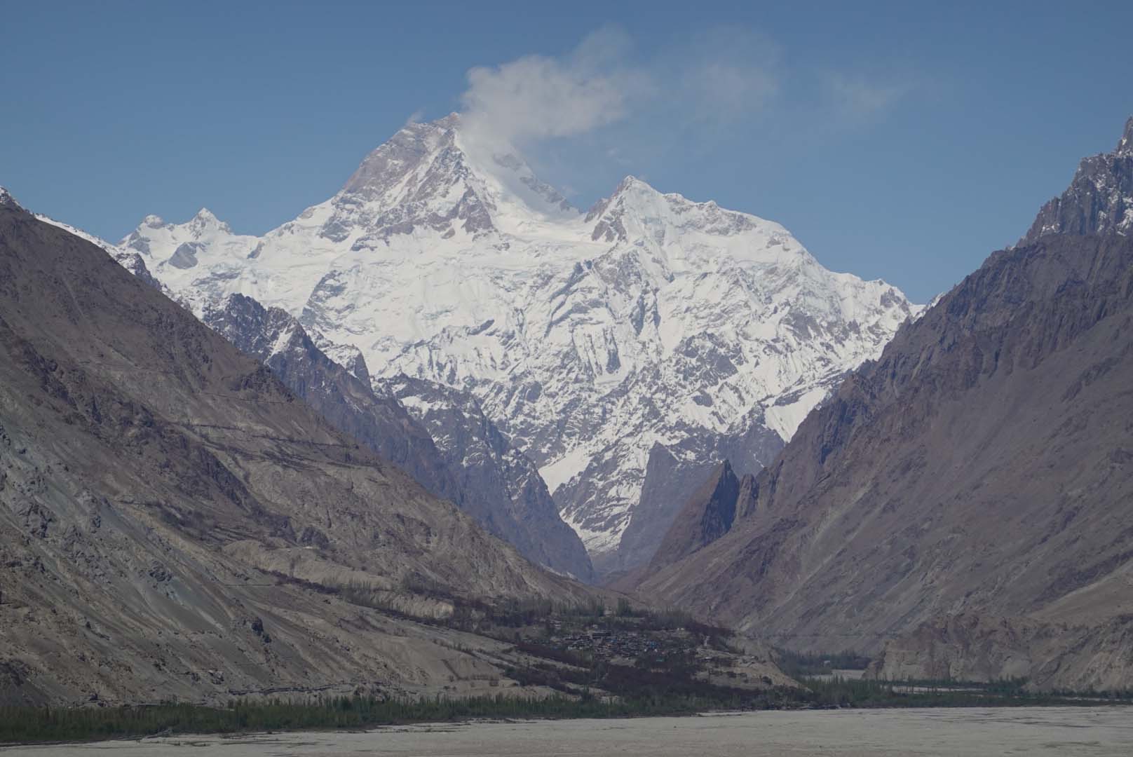
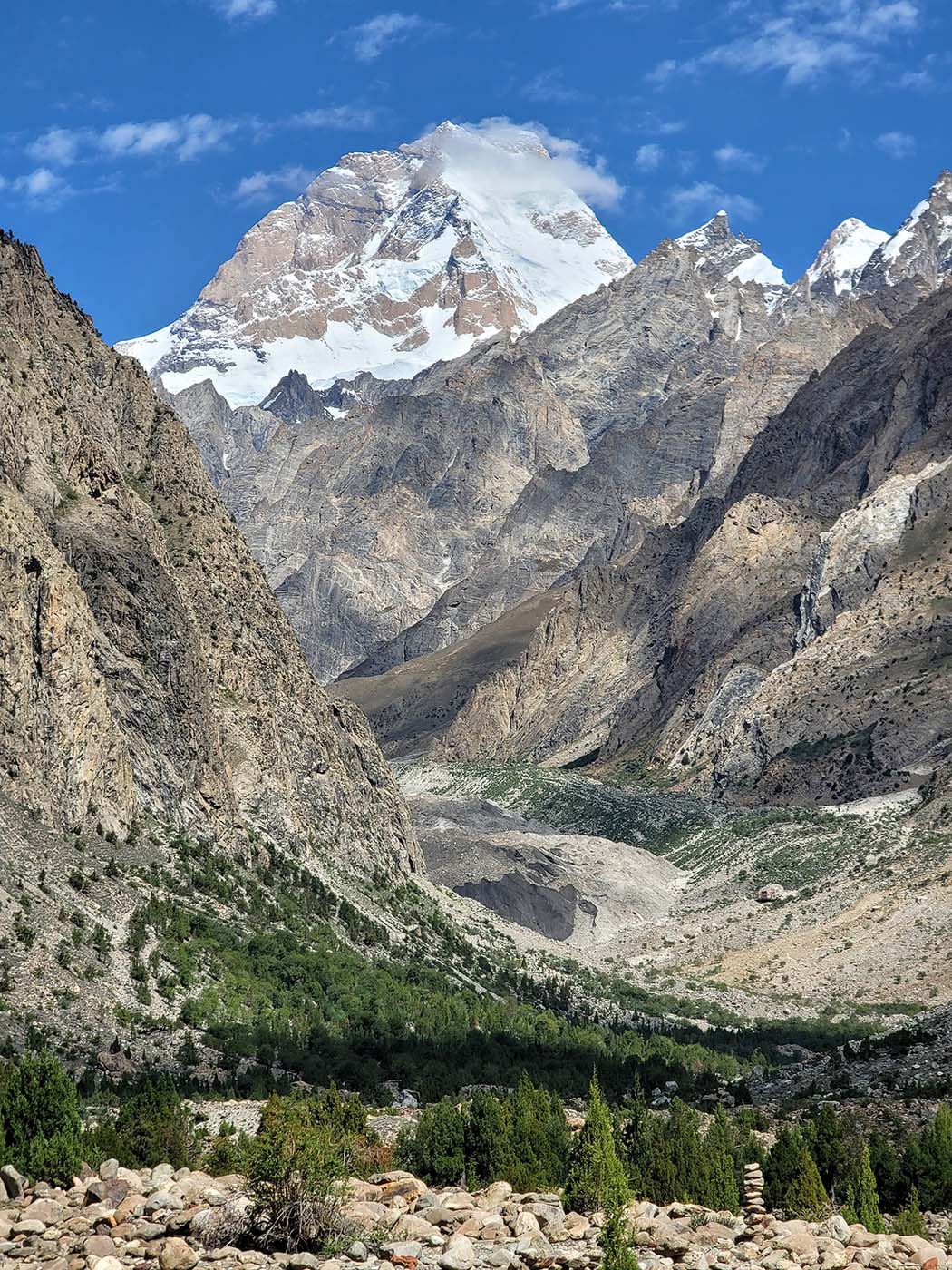
The numbers here are extraordinary. Over 5,000 metres of vertical relief within a compact area. Four peaks above 6,000 metres within a day’s walk of the village. Six major glacier systems: Aling, Masherbrum, Hushe, Gondogoro, Chogolisa, and Tsarak Tsa. Masherbrum, known as the Queen of the Karakoram, dominates the skyline. K6 (7,282m) and K7 (6,934m) rise from the Charakusa Valley to the south. Laila Peak (6,237m) draws both climbers and trekkers.

Very few places on earth concentrate this much alpine power within reach of a functioning village.

The Balti People of Hushe

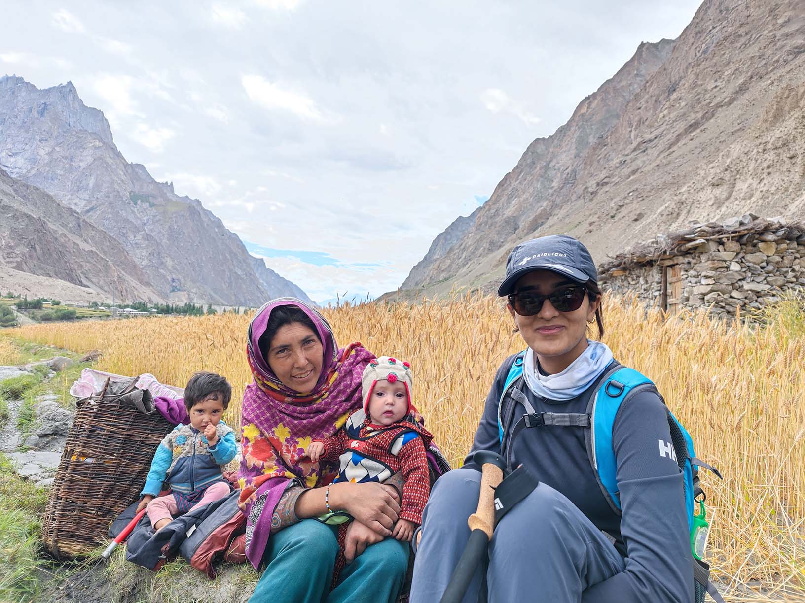
The Balti are descendants of Tibetan stock who have inhabited these valleys for centuries. Their language, Balti, carries ancient Tibetan roots; the word “brum” means mountain, giving Masherbrum its name. Their two-storey stone and wood houses are built to withstand avalanche risk: livestock on the ground floor, the family above.

Agriculture defines the rhythm of life here. Wheat, barley, and apricots grow in terraced fields set against grey granite walls. Every household maintains at least one female zmo, a hybrid of yak and cow, for milk, butter, and cheese. In summer, livestock move to high pastures between 4,500 and 5,500 metres. In winter, they return to the valley floor. This alpine transhumance has shaped the Balti relationship with altitude for generations.

Since the 1960s, Hushe’s men have worked as high-altitude porters, cooks, and guides for Karakoram expeditions. The mountaineering economy brought cash income and created a unique skill transfer across generations. Families pass climbing knowledge from father to son. The most recognised example is Little Karim, born in Hushe, who rose from porter to one of Pakistan’s most respected mountaineers.

Gateway to the Technical Karakoram

Hushe functions as the primary staging point for several of the Karakoram’s most technically demanding peaks. Its role is distinct from Askole, which serves K2. Hushe provides access to a concentrated cluster of 7,000-metre peaks within a compact radius.

Masherbrum Base Camp lies one to two days northeast of the village. The Charakusa Valley, accessed via Saicho junction at 3,350 metres, leads to the base camps of K6 and K7 over eight to ten days of trekking through glacier systems reaching 4,600 metres. The Gondogoro La pass at 5,585 metres connects Hushe Valley to Concordia on the Baltoro Glacier, near K2. This crossing, established as a trekking route in 1986, allows a circuit that few places in the world can offer: a K2 Base Camp trek combined with a high-altitude pass crossing, returning through Hushe rather than retracing the Baltoro approach.

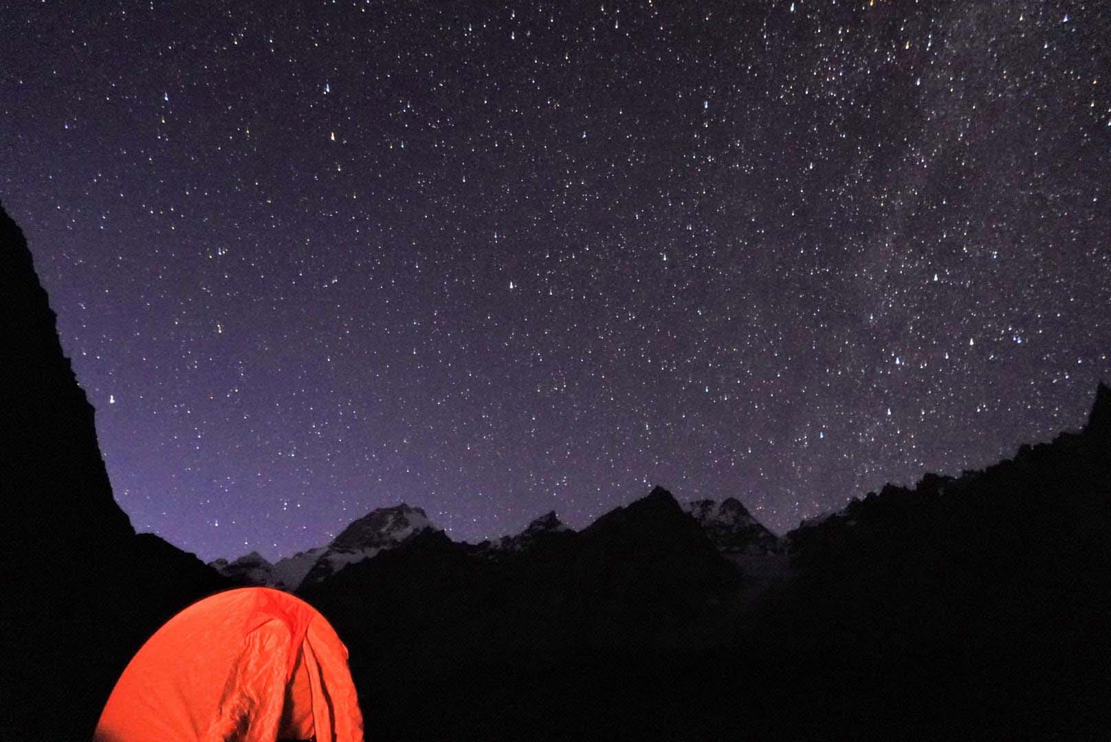
Climbing season runs from mid-June to mid-September, with optimal weather windows in July and August.

Why Hushe, Not Somewhere Else

Askole is a logistics stop. Trekkers pass through on their way to K2 Base Camp. Hushe is a destination in its own right: a living village surrounded by a cluster of technical peaks, with its own culture, agriculture, and mountaineering heritage.

Hunza has developed tourism infrastructure: hotels, restaurants, souvenir shops, paved roads. It serves a different purpose now. What Hushe offers instead is authenticity at a level that more developed valleys can no longer provide. No tourist shops. No queue culture. Children going to school, women working in fields, farmers harvesting wheat between granite walls that rise five thousand metres above them.

The combination is what makes it singular. A functioning traditional agricultural community at 3,100 metres, surrounded by six major glaciers and four peaks above 6,000 metres, connected by a high-altitude pass to the Baltoro Glacier system. The cultural and the alpine exist in the same frame.

BTV in Hushe Valley

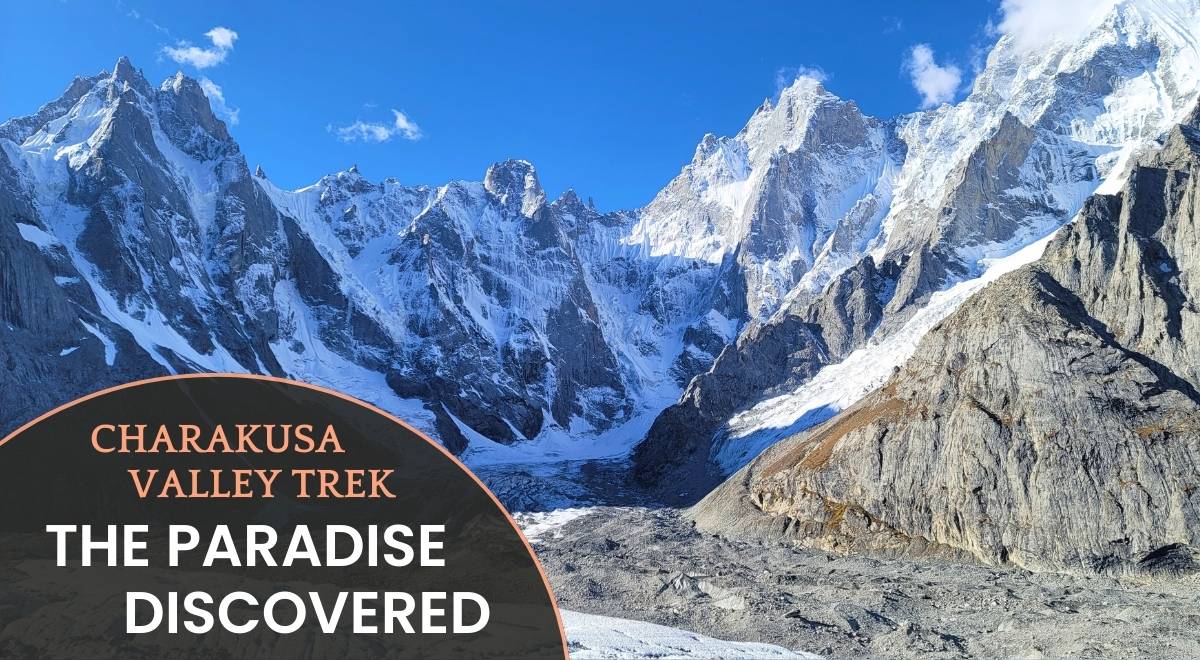
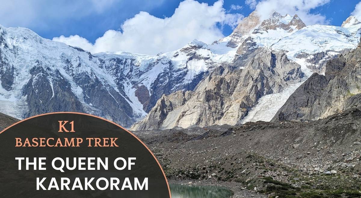
Two Beyond the Valley tours use Hushe as a base. The K1 Basecamp Trek drives through Baltistan to Hushe, crosses crop fields to Dumsum at 3,400 metres, and approaches Masherbrum Base Camp. The Charakusa Valley Trek stages from Hushe via Saicho junction into the Charakusa Glacier system toward K6 and K7.

Both routes are led by local Balti guides whose families have worked in these mountains for decades. The interactions with the community remain organic and unscripted, because the visitor numbers here are genuinely low. This is not a destination managing tourism fatigue. It is a place where the mountains, the glaciers, and the people who live among them still exist on their own terms.

Charakusa Valley Trek-Paradise Discovered

Charakusa Valley Trek – Paradise Discovered

Difficulty: Level 8
Trip Style: Basecamp / Hard / Trekking
Trip Length: 12 Days
Max Elevation: 4350m/14270ft (more)
CO2: 497kg

K1 Basecamp Trek-The Queen Of Karakoram

K1 Basecamp Trek – The Queen Of Karakoram

Difficulty: Level 4
Trip Style: Basecamp / Soft / Trekking
Trip Length: 11 Days
Max Elevation: 4200m/13800ft (more)
CO2: 480kg

or more
× Clear Filter

Type Filter

Destination
Trip Style
Month

loader-image
Gilgit, PK
2:27 pm, March 11, 2026
9°C
overcast clouds
92 %
1017 mb
7 mph
Wind Gust: 9 mph
Clouds: 100%
Visibility: 0.163 km
Sunrise: 6:19 am
Sunset: 6:06 pm

You have successfully subscribed to the newsletter

There was an error while trying to send your request. Please try again.

Beyond The Valley Adventures will use the information you provide on this form to be in touch with you and to provide updates and marketing.

Max elevation

HYDRATION

There is a correlation between daily fluid intake and successful acclimatization and you must pay particular attention to hydration during trekking at high altitudes. On treks to 3000 meters and above most people will need to drink between 4 and 6 liters each day to achieve suitable hydration levels and you must adopt a responsible approach to achieving this target.

ACUTE MOUNTAIN SICKNESS

Before embarking on a trek to high altitude it is important that you familiarize yourself with the signs and symptoms of Acute Mountain Sickness (AMS) and that you report any illness to your tip leader straight away. See the links at the bottom of this page for further reading on AMS.

DIAMOX

There are a number of untested herbal remedies which claim to prevent mountain sickness. However, only one drug is currently known to have a useful role in preventing AMS and to be safe for this purpose: acetazolamide (Diamox). We recommend that you carry Diamox in your first aid kit for treks where you spend an extended period above 4000m. Diamox can only be obtained from a medical professional on prescription and it is important that you first consult your own doctor so that you know there are no contra indications with other medicines you may be taking and that you do not have an allergy to acetazolamide. Diamox commonly causes some minor side effects, such as tingling fingers and toes, or a metallic taste in the mouth, but more severe reactions are rare. On trek, the decision whether or not and when, you should take Diamox as with any drug, will rest solely with you. If you intend to take Diamox, you must familiarize yourself with the appropriate dosage and regime prior to coming on the trip. The links at the bottom of this page will provide further information on the use of Diamox as an aid to acclimatization.

Travelling to high altitudes is not something you need to be scared of. Every year thousands of people enjoy the most amazing experiences in the world's greatest mountain ranges. Altitude sickness is entirely preventable if you follow very simple rules and procedures. Please make sure you are aware of these before you travel.

SUMMARY OF DIFFICULTY
The hike up to our campsite is a moderate 6 miles and 1400ft of elevation gain. The scramble up to Pyramid Ridge can be steep and difficult, but very adventurous and with just light day packs.Hiking

Distances
6-10 miBackpack Weight
25-35 lbsTerrain
Moderately RuggedMax Daily Elev. Gain
1950 ftHeights Exposure
Moderate

Please Note: Terrain, Elevation Gain and Heights Exposure ratings reflect the section or day of the trip with the maximum difficulty of each. Much of the trip is at easier levels. See the trip itinerary for more detailed information. Backpack Weight ratings are estimates that account for Wildland-provided gear, guest clothing, personal items and a share of group food. By packing light it’s often possible to stay on the lower end of the weight range. Pack weights also decrease during the trip.

PHYSICAL REQUIREMENTS

  • Hiking uphill or downhill with a 25-35 lb backpack for 5-7 hours
  • Hiking uphill off trail with a 8-12 lb backpack for 6-8 hours
  • Maintaining balance and footing on moderately rugged terrain
  • Hiking with moderate heights exposure

To show the relative difficulty of our adventure holidays, each trip is graded on a scale of 1 to 10, with 10 being the most challenging. Our simple, colour-coded grade symbol provides an indication of the difficulty of each trip.

Clearly, there are many different factors that contribute to the difficulty of a particular holiday, including, length of day, terrain, type of accommodation, altitude and weather conditions. Since some of these factors are necessarily changeable, any system of grades can only provide a general indication. If you have any questions about the nature of a particular trip or its suitability for you, please read the detailed Trip Notes and if you are still unsure, please do not hesitate to contact us

GREEN 1 - 4 LEISURELY

Suitable for most people in good health, holidays at this grade include only limited amounts of activity.

YELLOW 5 - 7 MODERATE

Suitable for reasonably fit individuals, such as weekend walkers and cyclists. There can be the occasional more difficult day.

RED 08 - 10 TOUGH

Our toughest holidays, involve many long days, often in isolated areas. A high level of fitness and previous wilderness experience is essential.

SUMMARY OF DIFFICULTY
The hike up to our campsite is a moderate 6 miles and 1400ft of elevation gain. The scramble up to Pyramid Ridge can be steep and difficult, but very adventurous and with just light day packs.Hiking

Distances
6-10 miBackpack Weight
25-35 lbsTerrain
Moderately RuggedMax Daily Elev. Gain
1950 ftHeights Exposure
Moderate

Please Note: Terrain, Elevation Gain and Heights Exposure ratings reflect the section or day of the trip with the maximum difficulty of each. Much of the trip is at easier levels. See the trip itinerary for more detailed information. Backpack Weight ratings are estimates that account for Wildland-provided gear, guest clothing, personal items and a share of group food. By packing light it’s often possible to stay on the lower end of the weight range. Pack weights also decrease during the trip.

PHYSICAL REQUIREMENTS

  • Hiking uphill or downhill with a 25-35 lb backpack for 5-7 hours
  • Hiking uphill off trail with a 8-12 lb backpack for 6-8 hours
  • Maintaining balance and footing on moderately rugged terrain
  • Hiking with moderate heights exposure
DIFFICULTY LEVEL

To show the relative difficulty of our adventure holidays, each trip is graded on a scale of 1 to 10, with 10 being the most challenging. Our simple, colour-coded grade symbol provides an indication of the difficulty of each trip.

Clearly, there are many different factors that contribute to the difficulty of a particular holiday, including, length of day, terrain, type of accommodation, altitude and weather conditions. Since some of these factors are necessarily changeable, any system of grades can only provide a general indication. If you have any questions about the nature of a particular trip or its suitability for you, please read the detailed Trip Notes and if you are still unsure, please do not hesitate to contact us

GREEN 1 - 4 LEISURELY

Suitable for most people in good health, holidays at this grade include only limited amounts of activity.

YELLOW 5 - 7 MODERATE

Suitable for reasonably fit individuals, such as weekend walkers and cyclists. There can be the occasional more difficult day.

RED 08 - 10 TOUGH

Our toughest holidays, involve many long days, often in isolated areas. A high level of fitness and previous wilderness experience is essential.