Thallay La Trek: The Green Side of the Karakoram

The Road Between Two Kingdoms

For centuries, this was the road between two kingdoms.

The pass at 4,800 metres connected Khaplu in the east to Shigar in the northwest. Traders crossed it with pack animals. Messengers carried word between royal courts. During British rule, surveyors preferred it over alternative routes because the meadows on either side offered ample grazing. The Karakoram is famous for its glaciers and granite, but Thallay La tells a different story. This is the green side of the range.

A Trek Through Alpine Meadows, Not Glaciers

Most treks in the Karakoram involve moraine fields, glacier crossings, and technical terrain. Thallay La is different. The route crosses alpine meadows, wildflower pastures, and shepherd settlements. No crampons. No ropes. No mountaineering experience required.

Trekkers approaching Thallay La pass in the Karakoram, Pakistan

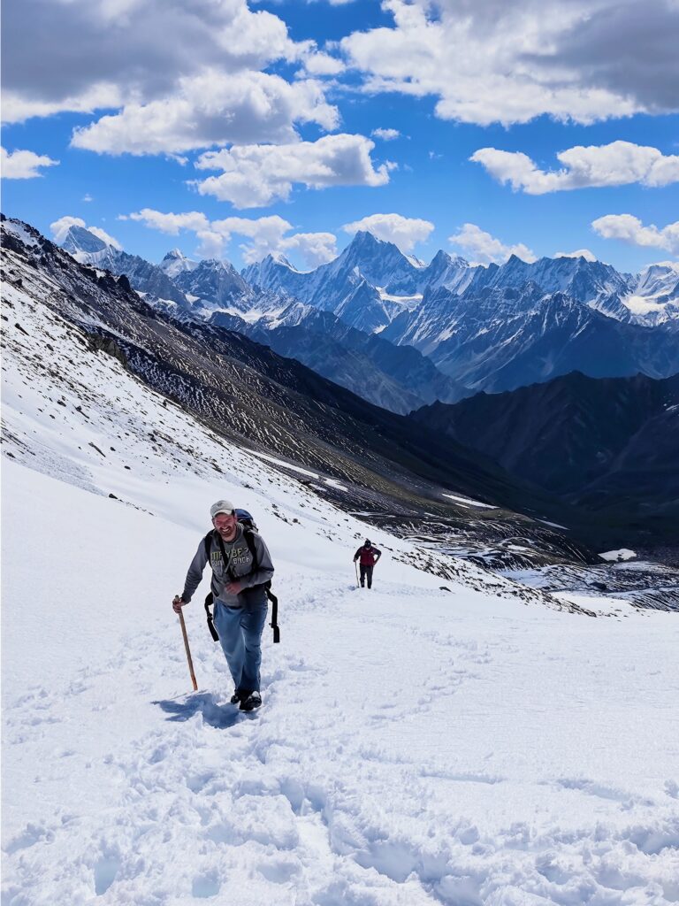
The trek begins from Khaplu, the old capital of the Yabgo dynasty in Ghanche District. A two hour drive brings you to Thallay Broq, the first campsite at the edge of the Thalle Lungma valley. From there, the trail climbs steadily through Balti pastoral land. Shepherd huts dot the hillsides. Livestock graze in high pastures. The air smells of wild herbs and cedar.

Over four to five days, the route covers 38.5 kilometres, rising from the valley floor to a high camp at 4,180 metres before crossing the pass itself. The descent follows the Bauma Lungma valley into Shigar, arriving at the ancient town in roughly four hours from the summit.

The entire journey connects two of Baltistan’s oldest settlements, each with its own fort, its own history, and its own character.

What You See From the Top

Alpine wildflowers at high camp near Thallay La with Karakoram peaks behind

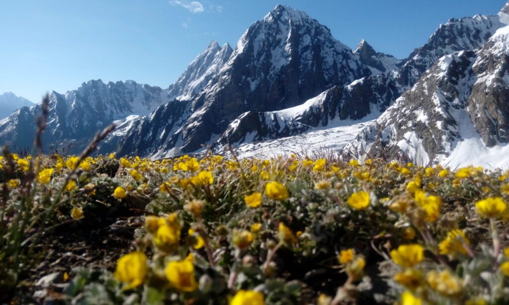
The summit of Thallay La offers a 360 degree panorama of the Karakoram. The Masherbrum range dominates the eastern horizon. Mango Gusor, at 6,288 metres, rises to the north. Below, the valleys extend in both directions, green and brown and glacial blue, the full spectrum of Baltistan’s landscape compressed into a single view.

This is the reward for four days of walking: a vantage point that shows you both sides of the range without requiring you to strap on technical gear.

Two Ancient Towns, One Trek

The trek’s starting and ending points are destinations in their own right.

Khaplu Palace at dusk, historic seat of the Yabgo dynasty in Gilgit-Baltistan

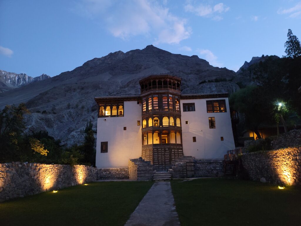
Khaplu was the seat of the Yabgo dynasty, the second largest kingdom in Baltistan. The Khaplu Palace, built in 1840, blends Tibetan, Kashmiri, Ladakhi, and Central Asian architectural styles. It has been restored by the Aga Khan Trust for Culture and now operates as a heritage hotel and museum. A few minutes away, Chaqchan Mosque has stood since 1370, making it one of the oldest in the region.

Shigar Fort heritage hotel, 17th century timber and stone architecture in Baltistan

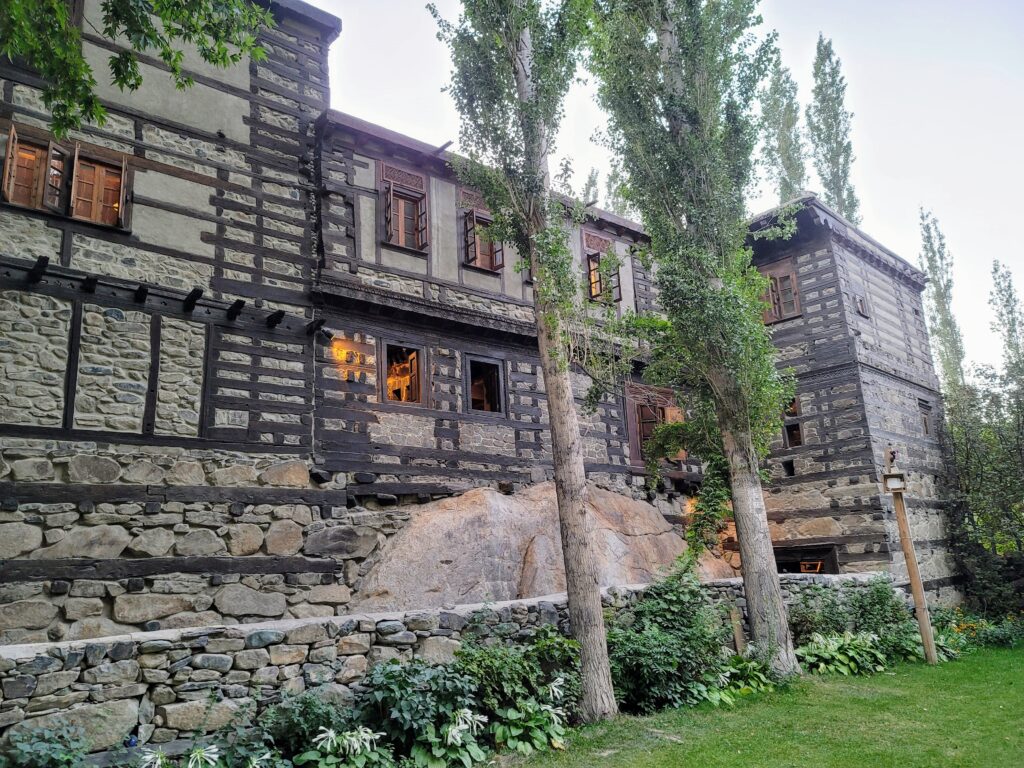
Shigar, on the western end, has its own fort (17th century, also restored as a heritage hotel) and sits at the gateway to the Shigar Valley, one of the primary approaches to K2 and the great glaciers of the central Karakoram.

Walking between these two towns is not just a trek. It is a passage through Baltistan’s history.

Who Is This Trek For

Thallay La is our introductory Karakoram trek. It is designed for travellers who want the experience of high altitude trekking in the Karakoram, the remoteness, the Balti communities, the mountain views, without the technical demands of routes like Gondogoro La or the Concordia circuit.

You need good general fitness and the ability to walk six to seven hours per day over uneven terrain. But you do not need climbing experience, glacier training, or specialised equipment.

The best window is June through August. July and August are ideal, with snow cleared from the pass and daytime temperatures comfortable for trekking. Nights at high camp drop to minus three to minus five degrees Celsius, so proper layering matters.

How We Run This Trek

Beyond the Valley operates two tours that include Thallay La. The Thallay La Trek is an 11 day programme with a maximum group size of 12 trekkers, starting from USD 2,286 per person. For those who want the full Baltistan experience, the Grand Traverse of Baltistan combines the Nangma Valley and Thallay La over 14 to 15 days.

Every guide on our Thallay La treks is from the valleys the route passes through. Our porters are local. Food is sourced from local farms and markets. The economic benefit of each trek stays in the communities that make the experience possible.

We are the first tour company in Pakistan to hold Travelife Sustainability Certification, and our Thallay La operations are designed to protect the alpine meadows that make this trek extraordinary. Small groups, waste management protocols, and community consultation before and after each season are built into how we operate.

The Green Karakoram Is Waiting

The Karakoram does not have to mean glaciers and granite. At Thallay La, it means wildflowers, shepherd huts, and a 4,800 metre pass that was old before the borders were drawn.

If you are considering your first trek in Pakistan, or if you want to see a side of the Karakoram that most visitors never reach, this is where to start.

View the full Thallay La Trek itinerary or get in touch to start planning your journey.

You have successfully subscribed to the newsletter

There was an error while trying to send your request. Please try again.

Beyond The Valley Adventures will use the information you provide on this form to be in touch with you and to provide updates and marketing.

Max elevation

HYDRATION

There is a correlation between daily fluid intake and successful acclimatization and you must pay particular attention to hydration during trekking at high altitudes. On treks to 3000 meters and above most people will need to drink between 4 and 6 liters each day to achieve suitable hydration levels and you must adopt a responsible approach to achieving this target.

ACUTE MOUNTAIN SICKNESS

Before embarking on a trek to high altitude it is important that you familiarize yourself with the signs and symptoms of Acute Mountain Sickness (AMS) and that you report any illness to your tip leader straight away. See the links at the bottom of this page for further reading on AMS.

DIAMOX

There are a number of untested herbal remedies which claim to prevent mountain sickness. However, only one drug is currently known to have a useful role in preventing AMS and to be safe for this purpose: acetazolamide (Diamox). We recommend that you carry Diamox in your first aid kit for treks where you spend an extended period above 4000m. Diamox can only be obtained from a medical professional on prescription and it is important that you first consult your own doctor so that you know there are no contra indications with other medicines you may be taking and that you do not have an allergy to acetazolamide. Diamox commonly causes some minor side effects, such as tingling fingers and toes, or a metallic taste in the mouth, but more severe reactions are rare. On trek, the decision whether or not and when, you should take Diamox as with any drug, will rest solely with you. If you intend to take Diamox, you must familiarize yourself with the appropriate dosage and regime prior to coming on the trip. The links at the bottom of this page will provide further information on the use of Diamox as an aid to acclimatization.

Travelling to high altitudes is not something you need to be scared of. Every year thousands of people enjoy the most amazing experiences in the world's greatest mountain ranges. Altitude sickness is entirely preventable if you follow very simple rules and procedures. Please make sure you are aware of these before you travel.

SUMMARY OF DIFFICULTY
The hike up to our campsite is a moderate 6 miles and 1400ft of elevation gain. The scramble up to Pyramid Ridge can be steep and difficult, but very adventurous and with just light day packs.Hiking

Distances
6-10 miBackpack Weight
25-35 lbsTerrain
Moderately RuggedMax Daily Elev. Gain
1950 ftHeights Exposure
Moderate

Please Note: Terrain, Elevation Gain and Heights Exposure ratings reflect the section or day of the trip with the maximum difficulty of each. Much of the trip is at easier levels. See the trip itinerary for more detailed information. Backpack Weight ratings are estimates that account for Wildland-provided gear, guest clothing, personal items and a share of group food. By packing light it’s often possible to stay on the lower end of the weight range. Pack weights also decrease during the trip.

PHYSICAL REQUIREMENTS

  • Hiking uphill or downhill with a 25-35 lb backpack for 5-7 hours
  • Hiking uphill off trail with a 8-12 lb backpack for 6-8 hours
  • Maintaining balance and footing on moderately rugged terrain
  • Hiking with moderate heights exposure

To show the relative difficulty of our adventure holidays, each trip is graded on a scale of 1 to 10, with 10 being the most challenging. Our simple, colour-coded grade symbol provides an indication of the difficulty of each trip.

Clearly, there are many different factors that contribute to the difficulty of a particular holiday, including, length of day, terrain, type of accommodation, altitude and weather conditions. Since some of these factors are necessarily changeable, any system of grades can only provide a general indication. If you have any questions about the nature of a particular trip or its suitability for you, please read the detailed Trip Notes and if you are still unsure, please do not hesitate to contact us

GREEN 1 - 4 LEISURELY

Suitable for most people in good health, holidays at this grade include only limited amounts of activity.

YELLOW 5 - 7 MODERATE

Suitable for reasonably fit individuals, such as weekend walkers and cyclists. There can be the occasional more difficult day.

RED 08 - 10 TOUGH

Our toughest holidays, involve many long days, often in isolated areas. A high level of fitness and previous wilderness experience is essential.

SUMMARY OF DIFFICULTY
The hike up to our campsite is a moderate 6 miles and 1400ft of elevation gain. The scramble up to Pyramid Ridge can be steep and difficult, but very adventurous and with just light day packs.Hiking

Distances
6-10 miBackpack Weight
25-35 lbsTerrain
Moderately RuggedMax Daily Elev. Gain
1950 ftHeights Exposure
Moderate

Please Note: Terrain, Elevation Gain and Heights Exposure ratings reflect the section or day of the trip with the maximum difficulty of each. Much of the trip is at easier levels. See the trip itinerary for more detailed information. Backpack Weight ratings are estimates that account for Wildland-provided gear, guest clothing, personal items and a share of group food. By packing light it’s often possible to stay on the lower end of the weight range. Pack weights also decrease during the trip.

PHYSICAL REQUIREMENTS

  • Hiking uphill or downhill with a 25-35 lb backpack for 5-7 hours
  • Hiking uphill off trail with a 8-12 lb backpack for 6-8 hours
  • Maintaining balance and footing on moderately rugged terrain
  • Hiking with moderate heights exposure
DIFFICULTY LEVEL

To show the relative difficulty of our adventure holidays, each trip is graded on a scale of 1 to 10, with 10 being the most challenging. Our simple, colour-coded grade symbol provides an indication of the difficulty of each trip.

Clearly, there are many different factors that contribute to the difficulty of a particular holiday, including, length of day, terrain, type of accommodation, altitude and weather conditions. Since some of these factors are necessarily changeable, any system of grades can only provide a general indication. If you have any questions about the nature of a particular trip or its suitability for you, please read the detailed Trip Notes and if you are still unsure, please do not hesitate to contact us

GREEN 1 - 4 LEISURELY

Suitable for most people in good health, holidays at this grade include only limited amounts of activity.

YELLOW 5 - 7 MODERATE

Suitable for reasonably fit individuals, such as weekend walkers and cyclists. There can be the occasional more difficult day.

RED 08 - 10 TOUGH

Our toughest holidays, involve many long days, often in isolated areas. A high level of fitness and previous wilderness experience is essential.