Login

Sign Up

After creating an account, you'll be able to track your payment status, track the confirmation and you can also rate the tour after you finished the tour.
Username*
Password*
Confirm Password*
First Name*
Last Name*
Birth Date*
Email*
Phone*
Country*
* Creating an account means you're okay with our Terms of Service and Privacy Statement.
Please agree to all the terms and conditions before proceeding to the next step

Already a member?

Login

Destination

Nangma Valley

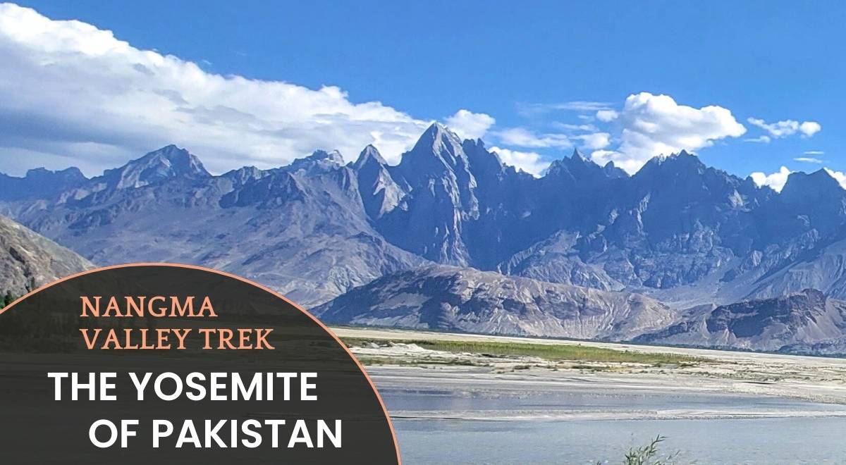
Nangma Valley Travel Guide: The Yosemite of Pakistan

Nangma camsite Kanday Pakistan

Located in Pakistan’s Karakoram range, Nangma Valley is a hidden gem where jagged peaks meet rich Balti traditions. Named among the 52 best places to visit in 2025 by New York Times, Nangma valley is ideal for trekkers, climbers, and culture seekers.  This untouched paradise offers world-class adventures, sustainable travel, and awe-inspiring vistas.

Get A Customized Tour - Beyond The Valley

Why Nangma Valley is a Top Adventure Destination

  • World-Class Climbing & Trekking:
    Conquer Amin Brakk (5,850m) and Drifika Peak (6,447m), or trek alpine meadows with panoramic Karakoram views.
  • Authentic Balti Culture:
    Engage with welcoming communities, savor traditional cuisine, and explore ancient villages.
  • Pristine Wilderness:
    Unspoiled trails, crystal streams, and star-lit campsites await eco-conscious travelers.

Nangma Valley Pakistan

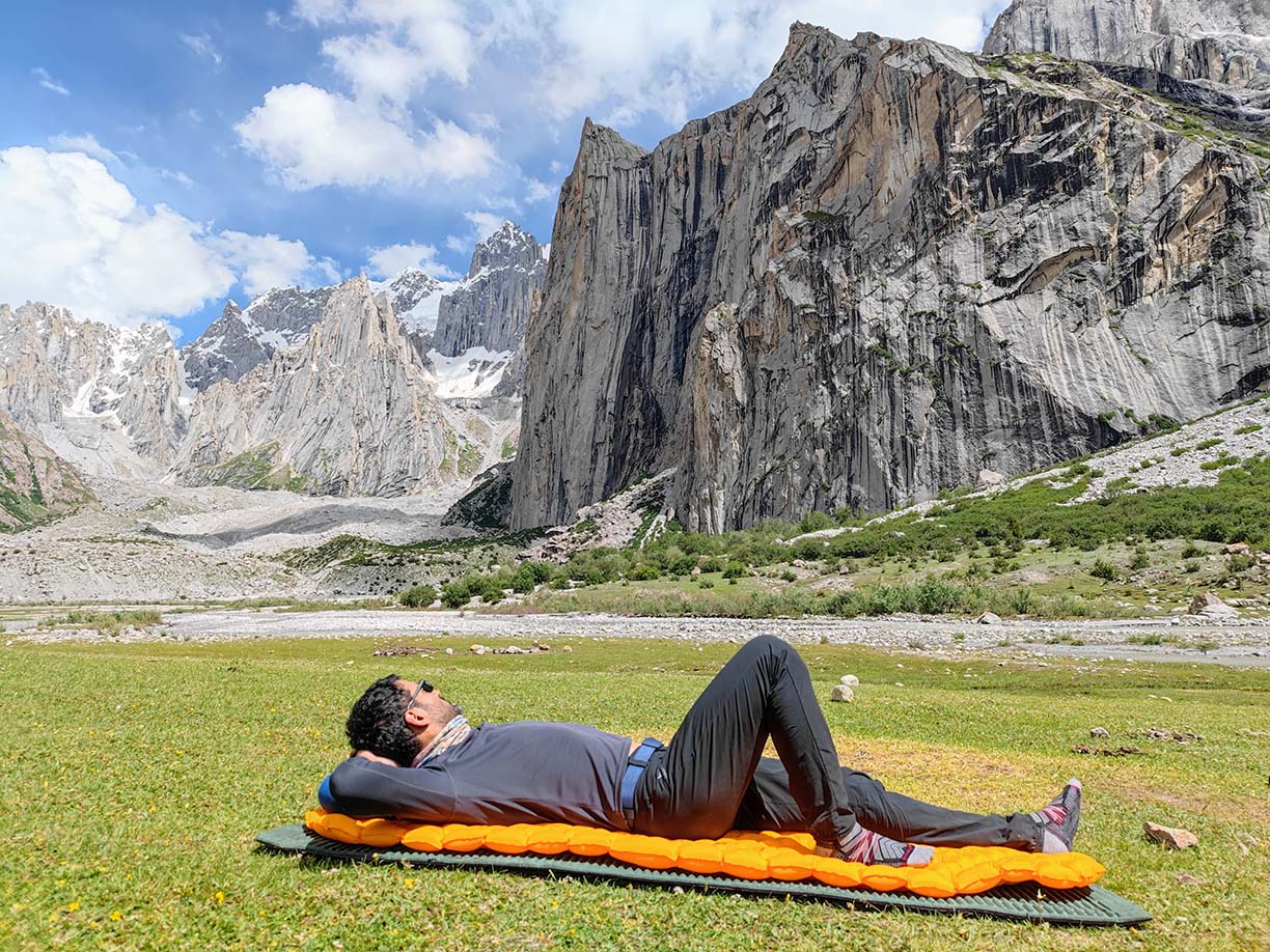
Epic Adventures in Nangma Valley

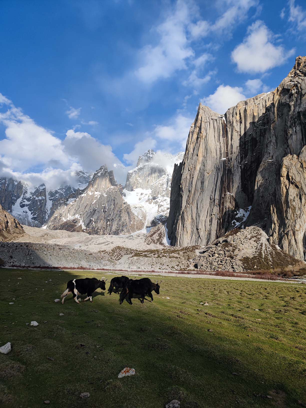
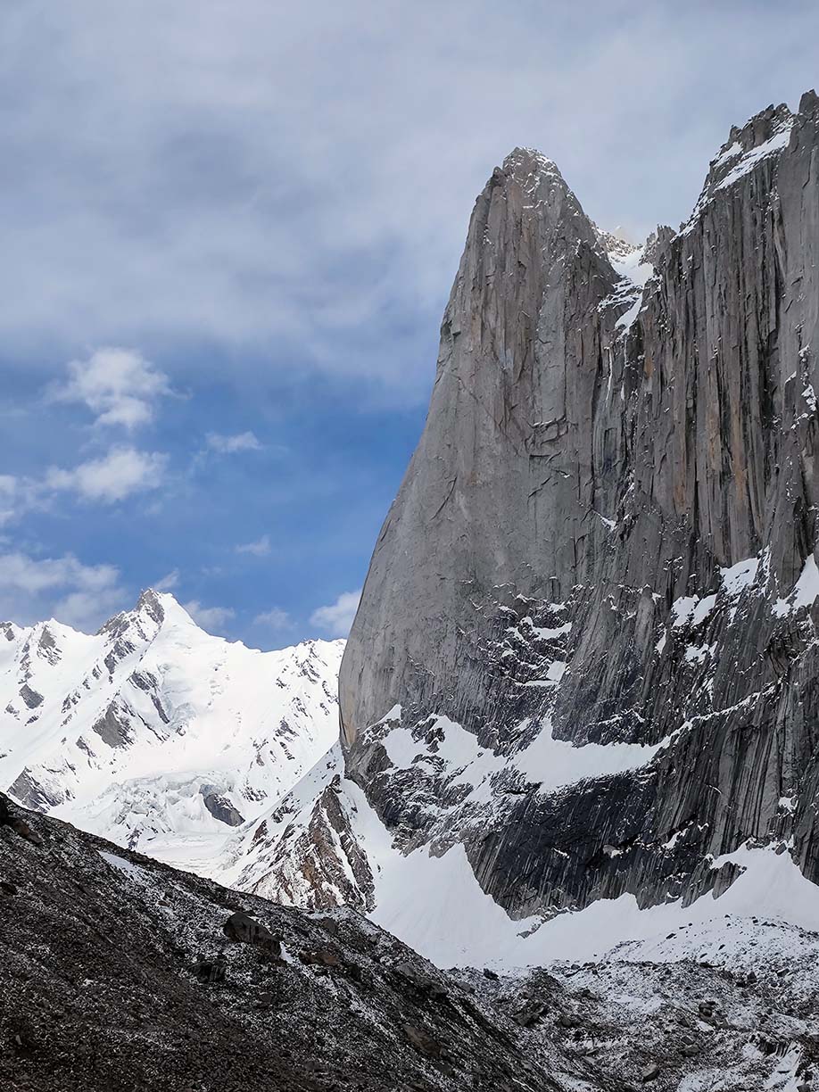
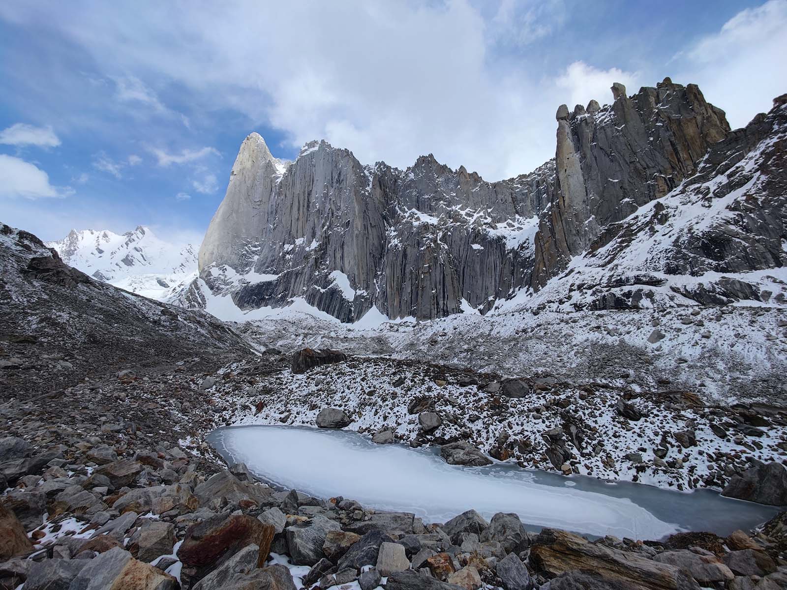
1. Climb Iconic Karakoram Peaks

  • Amin Brakk (Great Tower):
    A granite giant attracting elite climbers.
  • Drifika Peak:
    High-altitude challenges with rewarding vistas.

2. Trek Scenic Trails

  • Traverse flower-filled meadows, rugged ridges, and glacial valleys. Routes cater to all skill levels.

Amin Brakk Nangma Paksitan

Immerse in Authentic Balti Traditions

  • Cultural Experiences:
    Share stories with locals, enjoy apricot soup, or witness vibrant festivals.
  • Village Homestays:
    Learn centuries-old customs and crafts in stone-built settlements.

Sustainable Travel in Nangma Valley

  • Eco-Friendly Practices:
    Follow “Leave No Trace,” hire local guides, and support community-run lodges.
  • Preserve Heritage:
    Respect cultural norms and minimize environmental impact.

Amin Brakk Glacier Walk

Essential Travel Tips

  • Best Time to Visit:
    May–September for optimal weather.
  • Altitude Safety:
    Acclimatize gradually; carry medication.
  • Packing Guide:
    Sturdy gear, layers, and reusable water bottles.
  • Local Cuisine:
    Fuel up with dal, chapati, and dried apricots.
Nangma Valley Trek -The Yosemite of Pakistan

Nangma Valley Trek – The Yosemite of Pakistan

Difficulty: Level 4
Trip Style: Basecamp / Soft / Trekking
Trip Length: 10 Days
Max Elevation: 3950m/12950ft (more)

(1 Review)
or more
× Clear Filter

Type Filter

Destination
Trip Style
Month

loader-image
Gilgit, PK
1:44 am, February 19, 2025
temperature icon 0°C
overcast clouds
Humidity 61 %
Pressure 1028 mb
Wind 3 mph
Wind Gust: 3 mph
Visibility: 10 km
Sunrise: 6:45 am
Sunset: 5:47 pm

error: Content is protected !!

You have successfully subscribed to the newsletter

There was an error while trying to send your request. Please try again.

Beyond The Valley Adventures will use the information you provide on this form to be in touch with you and to provide updates and marketing.

Max elevation

HYDRATION

There is a correlation between daily fluid intake and successful acclimatization and you must pay particular attention to hydration during trekking at high altitudes. On treks to 3000 meters and above most people will need to drink between 4 and 6 liters each day to achieve suitable hydration levels and you must adopt a responsible approach to achieving this target.

ACUTE MOUNTAIN SICKNESS

Before embarking on a trek to high altitude it is important that you familiarize yourself with the signs and symptoms of Acute Mountain Sickness (AMS) and that you report any illness to your tip leader straight away. See the links at the bottom of this page for further reading on AMS.

DIAMOX

There are a number of untested herbal remedies which claim to prevent mountain sickness. However, only one drug is currently known to have a useful role in preventing AMS and to be safe for this purpose: acetazolamide (Diamox). We recommend that you carry Diamox in your first aid kit for treks where you spend an extended period above 4000m. Diamox can only be obtained from a medical professional on prescription and it is important that you first consult your own doctor so that you know there are no contra indications with other medicines you may be taking and that you do not have an allergy to acetazolamide. Diamox commonly causes some minor side effects, such as tingling fingers and toes, or a metallic taste in the mouth, but more severe reactions are rare. On trek, the decision whether or not and when, you should take Diamox as with any drug, will rest solely with you. If you intend to take Diamox, you must familiarize yourself with the appropriate dosage and regime prior to coming on the trip. The links at the bottom of this page will provide further information on the use of Diamox as an aid to acclimatization.

Travelling to high altitudes is not something you need to be scared of. Every year thousands of people enjoy the most amazing experiences in the world's greatest mountain ranges. Altitude sickness is entirely preventable if you follow very simple rules and procedures. Please make sure you are aware of these before you travel.

SUMMARY OF DIFFICULTY
The hike up to our campsite is a moderate 6 miles and 1400ft of elevation gain. The scramble up to Pyramid Ridge can be steep and difficult, but very adventurous and with just light day packs.Hiking

Distances
6-10 miBackpack Weight
25-35 lbsTerrain
Moderately RuggedMax Daily Elev. Gain
1950 ftHeights Exposure
Moderate

Please Note: Terrain, Elevation Gain and Heights Exposure ratings reflect the section or day of the trip with the maximum difficulty of each. Much of the trip is at easier levels. See the trip itinerary for more detailed information. Backpack Weight ratings are estimates that account for Wildland-provided gear, guest clothing, personal items and a share of group food. By packing light it’s often possible to stay on the lower end of the weight range. Pack weights also decrease during the trip.

PHYSICAL REQUIREMENTS

  • Hiking uphill or downhill with a 25-35 lb backpack for 5-7 hours
  • Hiking uphill off trail with a 8-12 lb backpack for 6-8 hours
  • Maintaining balance and footing on moderately rugged terrain
  • Hiking with moderate heights exposure

To show the relative difficulty of our adventure holidays, each trip is graded on a scale of 1 to 10, with 10 being the most challenging. Our simple, colour-coded grade symbol provides an indication of the difficulty of each trip.

Clearly, there are many different factors that contribute to the difficulty of a particular holiday, including, length of day, terrain, type of accommodation, altitude and weather conditions. Since some of these factors are necessarily changeable, any system of grades can only provide a general indication. If you have any questions about the nature of a particular trip or its suitability for you, please read the detailed Trip Notes and if you are still unsure, please do not hesitate to contact us

GREEN 1 - 4 LEISURELY

Suitable for most people in good health, holidays at this grade include only limited amounts of activity.

YELLOW 5 - 7 MODERATE

Suitable for reasonably fit individuals, such as weekend walkers and cyclists. There can be the occasional more difficult day.

RED 08 - 10 TOUGH

Our toughest holidays, involve many long days, often in isolated areas. A high level of fitness and previous wilderness experience is essential.

SUMMARY OF DIFFICULTY
The hike up to our campsite is a moderate 6 miles and 1400ft of elevation gain. The scramble up to Pyramid Ridge can be steep and difficult, but very adventurous and with just light day packs.Hiking

Distances
6-10 miBackpack Weight
25-35 lbsTerrain
Moderately RuggedMax Daily Elev. Gain
1950 ftHeights Exposure
Moderate

Please Note: Terrain, Elevation Gain and Heights Exposure ratings reflect the section or day of the trip with the maximum difficulty of each. Much of the trip is at easier levels. See the trip itinerary for more detailed information. Backpack Weight ratings are estimates that account for Wildland-provided gear, guest clothing, personal items and a share of group food. By packing light it’s often possible to stay on the lower end of the weight range. Pack weights also decrease during the trip.

PHYSICAL REQUIREMENTS

  • Hiking uphill or downhill with a 25-35 lb backpack for 5-7 hours
  • Hiking uphill off trail with a 8-12 lb backpack for 6-8 hours
  • Maintaining balance and footing on moderately rugged terrain
  • Hiking with moderate heights exposure
DIFFICULTY LEVEL

To show the relative difficulty of our adventure holidays, each trip is graded on a scale of 1 to 10, with 10 being the most challenging. Our simple, colour-coded grade symbol provides an indication of the difficulty of each trip.

Clearly, there are many different factors that contribute to the difficulty of a particular holiday, including, length of day, terrain, type of accommodation, altitude and weather conditions. Since some of these factors are necessarily changeable, any system of grades can only provide a general indication. If you have any questions about the nature of a particular trip or its suitability for you, please read the detailed Trip Notes and if you are still unsure, please do not hesitate to contact us

GREEN 1 - 4 LEISURELY

Suitable for most people in good health, holidays at this grade include only limited amounts of activity.

YELLOW 5 - 7 MODERATE

Suitable for reasonably fit individuals, such as weekend walkers and cyclists. There can be the occasional more difficult day.

RED 08 - 10 TOUGH

Our toughest holidays, involve many long days, often in isolated areas. A high level of fitness and previous wilderness experience is essential.